
Hidden Valley Flood Restoration
Restoring drainage.
Reducing future flood impacts.
After intense storm runoff moved mud, rocks, and debris through Hidden Valley, Washoe County crews focused on restoring the systems that help move stormwater safely: channels, culverts, detention basins, sediment capacity, and erosion-control rock.
5 locations
Highlighted restoration sites
2.5 inches
4,100 tons
Safety first
Flood Impact Tools


Hidden Valley Stormwater Abatement Tour
From flood impacts to restoration work
- Assess: Identify damaged drainage paths and blocked structures.
- Clear: Remove sediment, mud, boulders, brush, and debris.
- Restore: Rebuild basin capacity, channels, culverts, and flow paths.
- Reinforce: Use larger riprap and stabilization where erosion occurred.
Highlighted Work Locations
Restoration Locations
1. Hidden Valley Regional Park North Detention Basin
This channel captures stormwater and conveys it to a detention basin, where the water is temporarily stored and slowly released over time. The system also captures sediment from the highly erosive surrounding terrain.
During the flood, the channel and basin performed as designed, with floodwater peaking approximately two feet below the spillway.
Riprap is rock placed along waterways to absorb and deflect water energy, prevent soil erosion, and stabilize slopes against moving water or ice. Washoe County is replacing dislodged riprap with larger riprap reinforced with cement. The detention basin is also being excavated to restore its previous depth and capacity.
2. Top of Rough Rock Drive
This location is at the eastern edge of the neighborhood, at the mouth of the canyon. Two detention basins installed by the developer and formerly maintained by the HOA had not been maintained and were completely filled with sediment and vegetation. Even if properly maintained, the basins were never intended to contain floodwater of this magnitude.
During the flood, water filled the basins and debris clogged the culvert pipes, forcing water and mud over the sidewalk and into the neighborhood. This stormwater infrastructure is private and does not belong to Washoe County; however, the County is excavating sediment and debris to restore the basins to their originally designed condition.
3. Top of Gravel Court (TMWA Access Road)
At this location, scars on the mountainside show where water flowed down the mountain, cut through the canyon, and entered the neighborhood. The detention basin, formerly maintained by the HOA, was not designed or built to hold back floodwater. Because it had filled with sediment and become overgrown with brush, the flood quickly overflowed the basin and entered the neighborhood below.
Washoe County is excavating the accumulated debris and installing Class 300 riprap to stabilize the drainage area.
4. Silky Sullivan Lane
Washoe County maintains a channel along the east side of the neighborhood that serves as a barrier between undeveloped land and nearby homes. The channel conveys stormwater from south to north, beneath the street through a large-diameter culvert pipe, into natural drainage on the north side of the street, and out into undeveloped land.
This infrastructure is designed to convey stormwater. During the flood, boulders carried down the mountain lodged in the culvert and blocked the mud and rocks that followed. Water, boulders, and mud then backed up on the south side of the street, crested the roadway, and flowed into nearby homes. Washoe County cleared the clogged pipe and is restoring the channel to its pre-flood condition.
5. North End of Parkway Drive
This is the northeastern edge of the Hidden Valley neighborhood, where the valley continues north toward the Truckee River. During the flood, water, rocks, and mud traveled down the mountain to the terminus of Parkway Drive and into Steamboat Creek.
Areas north and east of Hidden Valley were also affected, including the Truckee Meadows Water Reclamation Facility. To the east, Storey County experienced widespread flooding in Lockwood, which is located above the Truckee River.
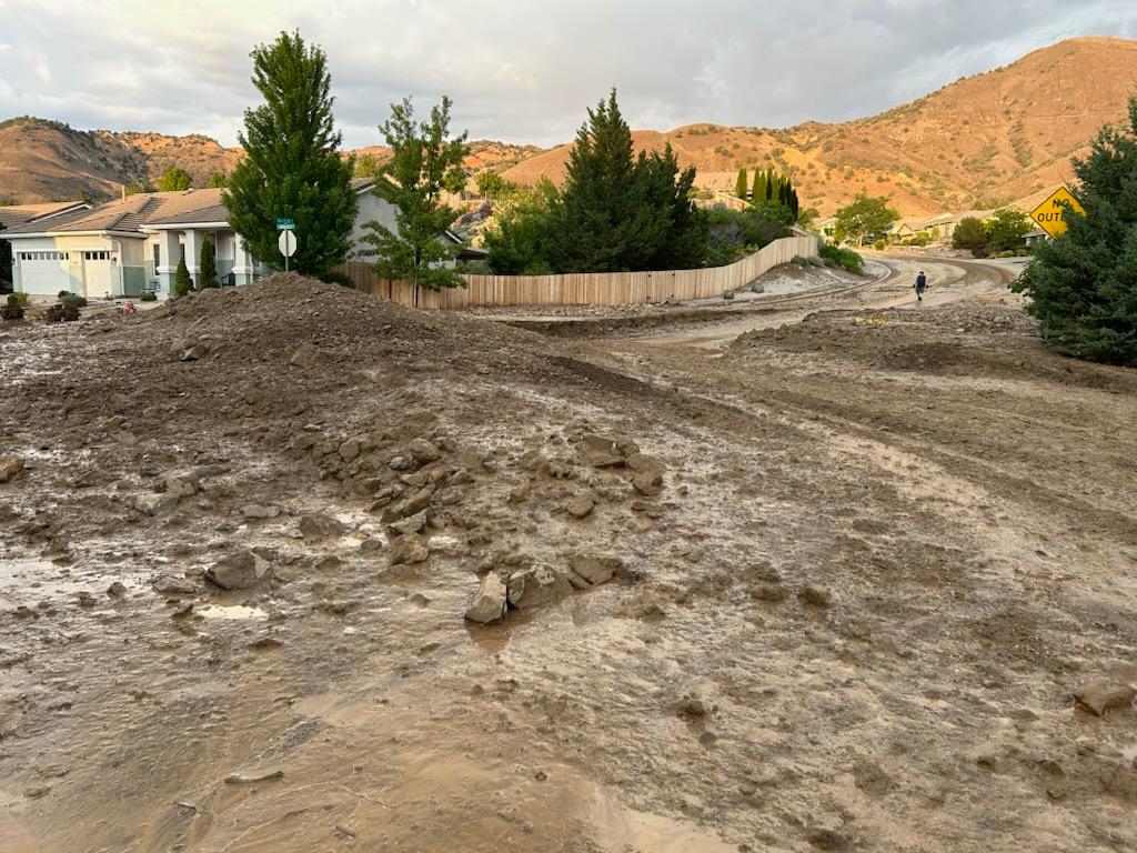
2024 Hidden Valley Flood
Washoe County Roads crews cleared nearly 16,000 cubic yards of mud and debris from the Hidden Valley neighborhood after a flash flood on July 21, 2024. Approximately 100 homes were affected by the flood.
Washoe County Community Services Department (CSD) cleared roads while the Red Cross conducted damage assessments on and assisted residents in identifying resources they need to make their homes more habitable, particularly those whose insurance will not cover damage from the flood and debris. Team Rubicon also monitored the situation for potential response.
The National Weather Service confirmed that a resident’s home weather station recorded a downpour the equivalent of a 200-year flood. 1.3 inches of rain fell in the span of 45 minutes. This means that this level of storm only has a 1:200 – or .05 percent – change of happening in any given year.
After a week of cleanup, CSD hauled 15,800 cubic yards of debris from the neighborhood and stored 5,000 cubic loads in its Roads yard – the equivalent of 600 truck loads. CSD additionally removed 10,800 cubic yards of mud and debris from Hidden Valley Regional Park, which bore the brunt of the debris flow.